When the Ice Lightens: Why West Antarctica Is Rising
GPS and satellite gravity data reveal unusually rapid bedrock uplift in West Antarctica—and why it matters for ice and sea-level research.
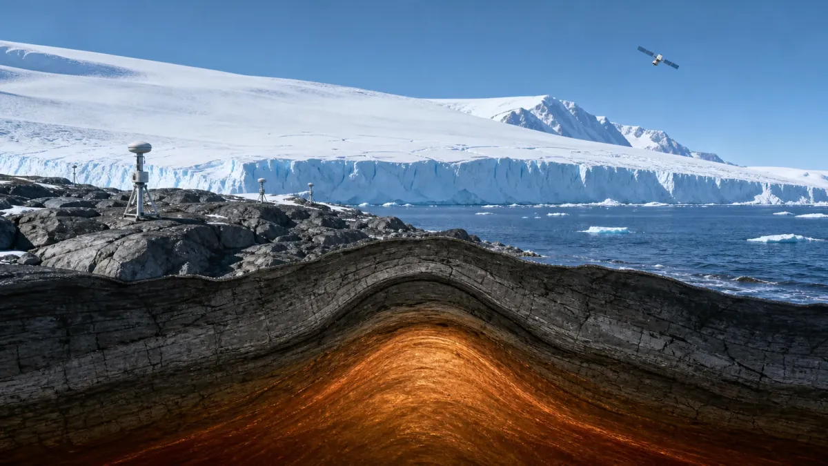
West Antarctica is losing ice, yet the ground beneath part of it is moving upward at an exceptional pace. GPS stations near the Amundsen Sea have measured bedrock uplift of up to 41 millimetres per year. The finding reveals a surprisingly responsive mantle—and changes how scientists model ice loss and future sea level.
An ice sheet does not rest on an immovable platform. It sits on a planet that bends under weight and slowly changes shape when that weight is removed. In West Antarctica, this solid-Earth response is fast enough to be observed over decades.
A continent rising beneath the ice
A 2018 study in Science used GPS stations across the Amundsen Sea Embayment to measure vertical bedrock motion. This sector of West Antarctica includes some of the continent’s most closely watched glaciers, including Pine Island and Thwaites.
At some GPS sites, the researchers found uplift rates as high as 41 millimetres per year—among the fastest recorded in a glaciated region. The number is local, not an average for the whole continent, but it was large enough to challenge the Earth models then commonly used for Antarctica.
Much of the familiar post-glacial rebound in places such as Scandinavia and Canada is a response to ice that disappeared thousands of years ago. Around the Amundsen Sea, the ground appears able to respond to ice loss on the scale of centuries and even decades.
The mantle is solid, but it can still flow
The mechanism begins with load. A thick ice sheet presses the crust downward and displaces material in the mantle below. When the ice becomes thinner, part of that load is removed and the bedrock rises.
There are two related responses. The first is elastic: the crust springs upward as the load changes. The second is viscoelastic: mantle rock gradually deforms and redistributes beneath the crust.
Calling the mantle “fluid” can be misleading. It is not a global ocean of molten rock. It is mostly solid, but heat, pressure and time allow it to deform like an extremely viscous material. How quickly it responds depends strongly on temperature, composition and regional geology.
The mantle beneath parts of West Antarctica has unusually low viscosity. West Antarctica also differs geologically from the older, more stable interior beneath much of East Antarctica. Its thinner lithosphere and rift history help explain why a single uniform Earth model cannot represent the entire continent well.
How scientists measure motion they cannot see
GPS instruments anchored to exposed rock provide one part of the answer. By tracking their position over time, researchers can measure vertical movement with millimetre-scale precision.
The European Space Agency’s GOCE mission supplied another piece. From 2009 to 2013, GOCE mapped tiny variations in Earth’s gravity field. Those variations contain information about how mass is distributed through the crust, lithosphere and mantle.
GPS tells scientists how fast particular locations are moving. Gravity and seismic data help them build models of the structure that makes such movement possible. The combination turns a surface observation into evidence about processes far below the ice.
Why uplift can affect the ice sheet
Much of the West Antarctic Ice Sheet is grounded below sea level. The point where grounded ice begins to float is called the grounding line, and its position is critical to ice-sheet stability.
If bedrock rises near the grounding line, the local water depth and bed slope can change. Under some conditions, that can slow the retreat of grounded ice. Scientists describe this as a negative feedback: ice loss unloads the bedrock, uplift follows, and the uplift can partly resist further retreat.
The word partly matters. Bedrock uplift does not cancel ocean warming, atmospheric warming or ice-shelf thinning. It does not make sea-level rise disappear. The strength of the feedback depends on local topography, mantle viscosity, ocean conditions and the speed at which the ice changes.
A 2025 modelling study in Nature Communications reinforced the importance of this interaction. When researchers used three-dimensional Earth structures instead of treating the bedrock as rigid, the modelled Antarctic contribution to sea-level rise was lower over the coming centuries. In some of the tested simulations, the difference reached 23 per cent by 2500. That is a meaningful correction to long-term projections, but it is not a rescue mechanism.
The same movement can complicate measurements
Satellites can estimate ice-mass change by detecting variations in gravity. But rising bedrock also moves mass. To isolate the signal from disappearing ice, researchers must correct for changes in the solid Earth below it.
This is one reason mantle structure matters far beyond geology. An inaccurate correction can distort estimates of how much ice has already been lost. An oversimplified bedrock model can also change projections of where grounding lines may retreat in the future.
The system is connected:
- Warm ocean water can thin floating ice shelves from below.
- Weaker ice shelves provide less resistance to glaciers flowing from land.
- Loss of grounded ice reduces the load on the crust.
- The bedrock rises and alters water depth, slope and grounding-line geometry.
Climate observations are therefore not weakened by the fact that Earth is moving. They become more accurate when that movement is measured and included. Ponett has explored the broader distinction between short-term variation and long-term physical expectations in The Climate Is Behaving as Expected.
Old satellite data, new scientific value
GOCE completed its mission in 2013, but its gravity maps remain useful. When older satellite observations are combined with longer GPS records, improved seismic models and better ice-sheet simulations, they can answer questions that were difficult to frame when the satellite was still flying.
That is the larger lesson from West Antarctica. Ice research is not only about measuring ice. It requires oceanography, geodesy, satellite gravity, seismology and the physics of solid rock moving over time.
In brief
Bedrock near the Amundsen Sea has been observed rising by up to 41 millimetres per year. The rapid uplift points to a low-viscosity mantle beneath West Antarctica and shows that the region can respond to relatively recent ice loss.
GPS measures the motion, while GOCE gravity data and seismic observations help explain it. Including this solid-Earth response gives scientists better estimates of past ice loss and more realistic projections of how Antarctica may contribute to future sea level.
Sources and further reading
- Science: Observed rapid bedrock uplift in Amundsen Sea Embayment promotes ice-sheet stability
- ESA: Earth’s squishy interior gives rapid rise to Antarctica
- DTU Research Database: Study record and abstract
- Nature Communications: Bedrock uplift reduces Antarctic sea-level contribution over next centuries



Leave a Reply
You must be logged in to post a comment.